


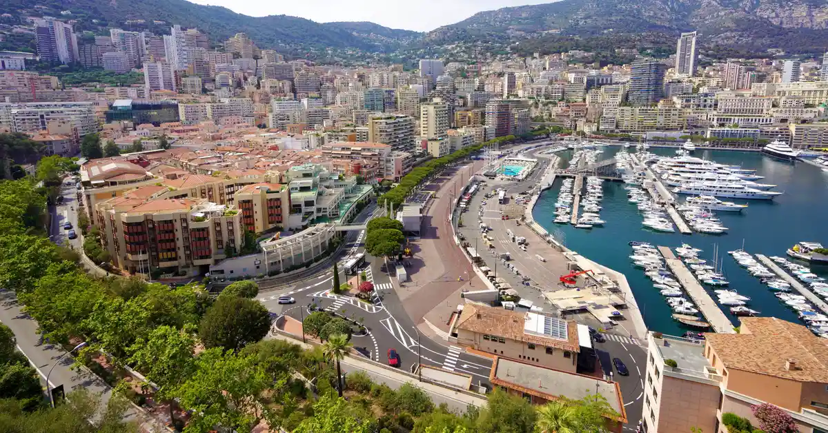
The geography of Monaco is the story of a tiny city-state located along the Mediterranean, with an area of only about 2 km² and surrounded by France on three sides. On the strip of land sloping from the foothills of the Alps to the sea, Monaco has become one of the most densely urbanised places on the planet.
Contents
Overview of Monaco’s geography
When talking about the geography of Monaco, the first thing that impresses is its size. This is the second-smallest sovereign state in the world, after the Vatican, with a total area of about 2 km². The entire territory is nestled on a narrow coastal strip in the Riviera region, where the Alps in the south descend directly into the Mediterranean.
This country is located in Western Europe, close to the southeastern border of France and not far from the Italian border. In fact, the country of Monaco it is surrounded by French territory on all three land sides, while the other side opens to the sea. This position, wedged between the mountains and the sea, shapes almost every natural feature as well as how people organise their living space here.
Because the area is so small, every square metre in Monaco is of great value. This country has no countryside in the conventional sense, no large rivers or wide plains, and most of the surface has been urbanised. It is this scarcity of land that is the key factor explaining why Monaco develops vertically and constantly seeks to expand into the sea.
Considering a residency programme? The Prosperous Living Investment team assesses your profile free of charge and advises on the pathway that fits your goals.
Location on the Mediterranean Riviera
Monaco is located on the coastline often called the Riviera, the famous coastal strip stretching between southern France and northwestern Italy. This is an area with a characteristic landscape: cliffs near the sea, small bays, and towns clinging to the slopes overlooking the blue water.
The Mediterranean location gives Monaco an advantage in both climate and maritime transport. The country is located near large French cities like Nice, and is not too far from the Italian border. As a result, Monaco has become a convenient meeting point for the flow of tourists, workers, and investors moving through the region.
The coastline of Monaco, though short, plays a central role in national life. The sea is not just a landscape but also an economic space: marinas, ports, and water-based entertainment activities are closely tied to the image of this city-state. It can be said that the sea is both a natural boundary and a vital resource for Monaco.
Borders and territorial relations with France
A special feature of Monaco’s geography is that the entire land border of this country is adjacent to only one country, France. French administrative areas surround Monaco from the north, east, and west, making the city-state a type of territory almost embedded within its neighbour’s land.
This geographical attachment entails a close relationship regarding infrastructure and daily life. Most people working in Monaco reside in neighbouring French and Italian towns, travelling daily across the border, which has no clear barriers. Monaco’s road network, railways, and public services are therefore closely connected to the French system.
Because there is no wide geographical buffer, Monaco almost shares a continuous urban space with the adjacent French towns. The national border in many places is just streets or buildings, making it difficult for outsiders to realise they have stepped from one country to another. This feature clearly reflects the nature of a tiny city-state in the heart of Europe.
Terrain sloping from the foothills of the Alps to the sea
Terrain is one of the most powerful factors shaping the appearance of Monaco. The country lies on the slopes where the final hills of the pre-Alps gradually lower and then descend into the Mediterranean. The result is a territory with almost no wide flat ground, with significant elevation changes over very short distances.
From the water’s edge to the higher ground inland, the terrain rises rapidly, forming layered terraces and slopes. Consequently, many streets in Monaco must wind along contour lines, accompanied by stairs, ramps, and public lift and escalator systems to assist residents in navigating between different elevations.
This rugged topography is both a challenge and a defining characteristic. It limits the land available for development and increases infrastructure costs, yet it simultaneously creates impressive tiered views of the sea. Effectively leveraging these slopes has become a core element of the city-state’s planning.
Districts and wards of Monaco
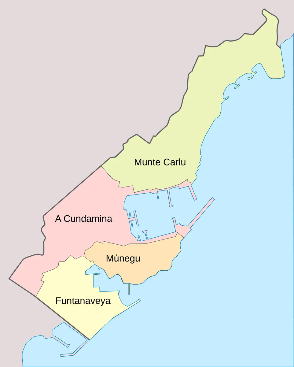
Despite its small size, Monaco is divided into several districts, each with its own distinct identity. The four most frequently mentioned are Monte Carlo, La Condamine, Monaco-Ville, and Fontvieille. Each district reflects a different layer of history and function within the nation’s spatial structure.
Monte Carlo is located in the northeast, synonymous with casinos, luxury hotels, and world-class events. It is the district most widely known to international visitors and is often viewed as the symbol of Monaco’s opulent lifestyle.
La Condamine is the area surrounding the main harbour, serving as a vibrant commercial and residential hub. Meanwhile, Monaco-Ville, also known as the old town, sits on a rocky promontory jutting into the sea, housing the royal palace and the city-state’s oldest historical structures.
Fontvieille is the youngest district, formed largely on reclaimed land in the southwest. It is a prime example of Monaco’s efforts to expand its territory, combining residential areas, green spaces, sports facilities, and a small harbour. The diversity between these districts demonstrates how a tiny nation manages to organise multiple layers of urban function.
Fontvieille and land reclamation projects to expand the area
One of the most notable stories of Monaco’s geography is the nation’s proactive expansion of its territory by reclaiming land from the sea. As natural land reserves were nearly exhausted, land reclamation became the only viable path to create additional space for residents and economic activity.
The Fontvieille district is the clearest result of this strategy. Most of the district’s area was created from what was previously coastal water, through an elaborate process of filling and embankment construction. On this new land, Monaco has developed housing, parks, a stadium, and service areas, thereby easing the pressure on the original territory.
In recent decades, Monaco has continued to implement further land reclamation projects to supplement its supply of prime land. Such projects require complex engineering to ensure foundation stability and limit the impact on the marine environment. The exact scale of these reclaimed areas may change over time and should be verified through official sources.
Land reclamation highlights the unique relationship between Monaco and the water. The sea is not merely a boundary but a space where the nation seeks additional area to survive and thrive. This is a rare characteristic, tied to land pressures that few other nations face to a similar degree.
Mild Mediterranean climate
Monaco enjoys a characteristic Mediterranean climate, with warm, dry summers and mild, more humid winters. Thanks to its coastal location and the protection of hills to the north, the nation avoids most severe cold spells, creating pleasant weather conditions for most of the year.
Abundant sunshine is one of the attractions of the Riviera in general and Monaco in particular. The sea acts as a regulator, ensuring that temperature fluctuations between day and night, as well as between seasons, are not too extreme. Rain is typically concentrated in the cooler months, sometimes in the form of short downpours.
This warm climate is one of the reasons the area has long been a favoured holiday destination. Favourable weather supports outdoor activities, from sea-based recreation to year-round sporting and cultural events, contributing to the city-state’s image on the Mediterranean coast.
Highest population density in the world
The combination of an extremely small area and a concentrated population means Monaco is often ranked among the highest in the world for population density. Per unit of area, the number of people living here far exceeds most other countries and cities, turning the entire nation into a nearly continuous, densely packed urban area.
This high density is a direct consequence of geographical limitations. As it cannot expand much inland due to being surrounded by France and blocked by mountains, the population is forced into a narrow space. This pressure is reflected in very high real estate prices and intense competition for every plot of building land.
To better understand the scale and composition of the population, one can refer to the in-depth article on Demographics of Monaco. According to the national statistics agency Monaco Statistics, population data is updated periodically and serves as a reliable reference for accurate figures.
High density creates both advantages and challenges. On one hand, it helps centralise services and infrastructure, keeping travel distances short. On the other hand, it imposes strict requirements on planning, transport, and public space to maintain quality of life in a confined environment.
Vertical urban planning
Faced with land pressure, Monaco has chosen to develop vertically as an inevitable solution. High-rise buildings have sprung up densely, making maximum use of vertical space to compensate for the scarcity of ground area. The city-state’s skyline is therefore heavily defined by multi-storey structures clinging to the slopes.
Planning here does not stop at building upwards but also exploits underground space and connecting levels. Car parks, tunnels, walkways, and some transport routes are located underground or integrated into the hillsides, helping to free up the surface for buildings and public space. The system of public lifts and escalators connecting different elevations is a familiar part of urban life.
This multi-layered spatial organisation makes Monaco a prime example of a compact city. Every function, from housing and offices to entertainment, is stacked and interwoven within a limited area. This is also a factor that creates a clear distinction between Monaco and most other nations in the world.
Vertical development is also linked to the nation’s specific economic activities. The density of high-end buildings reflects real estate values and the appeal of Monaco economy to investors, a high-income service economy concentrated in a very small, narrow space.
Ports and sea frontage in the territorial structure
The harbour holds a central position in Monaco’s territorial structure. The main harbour, located in the La Condamine area, is where many yachts moor and is an image synonymous with the city-state on the Mediterranean coast. The water is utilised as an economic space and a symbol of the high-end lifestyle here.
In addition to the main harbour, Monaco also has a smaller marina in the Fontvieille district, serving further mooring needs and coastal activities. The arrangement of multiple water access points reflects the importance of the sea in the nation’s life and image. The sea both expands the usable space and enhances the landscape value.
The close connection between land and sea is a thread running through Monaco’s geography. From reclaimed areas to the harbour system, the nation is constantly reshaping its coastline to adapt to its area limitations. This proactivity shows how a tiny territory turns natural constraints into its own unique characteristics.
Accompanying you on your journey in residency investment
The Prosperous Living Investment team advises on pathways, assesses profiles and manages investments transparently for every residency, citizenship and international property objective.
Free profile assessmentWhere life gets prosperous