


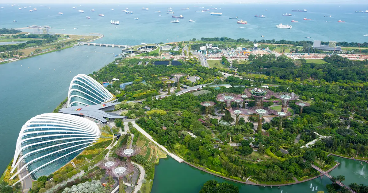
Singapore’s geography has been both a weakness and a strength that shaped the island nation’s history and development. With a total area of only about 735 km² and no significant natural resources, Singapore has turned its strategic location at the crossroads of global shipping routes into its core competitive advantage.
This article analyses Singapore’s location, terrain, climate, water resources, land reclamation projects and ecosystems, based on official data from specialised agencies such as the Maritime and Port Authority, the Urban Redevelopment Authority and the National Environment Agency. It provides essential background for understanding the island nation.
Detailed article onSingapore.
Message
Singapore’s strategic geographic location
Singapore lies at about 1°22′ North and 103°48′ East, just 137 km north of the equator. This location places the island nation at an important junction between the Indian Ocean and the Pacific Ocean, overlooking some of the busiest shipping straits in the world: the Strait of Malacca and the Singapore Strait.
To the north, Singapore borders the Malaysian state of Johor across the Straits of Johor, just 1 km wide at its narrowest point. To the south, the island nation faces Indonesia’s Riau Islands across the Singapore Strait. To the west lies the Strait of Malacca — a shipping route that carries about a third of global seaborne trade each year. To the east is the South China Sea.
This strategic location is a fundamental factor in Singapore’s geography. According to data from theMaritime and Port Authority of Singapore (MPA), the Port of Singapore is currently one of the busiest container ports in the world, handling more than 39 million TEU a year. The island nation is also the world’s largest marine bunkering hub, serving most of the commercial vessels passing through the region.
Changi International Airport, on the east of the main island, also takes advantage of this location to be one of the busiest airports in the Asia-Pacific. Changi connects to more than 380 cities in over 100 countries, reinforcing its role as an aviation bridge between continents.
Singapore lies in a stable tropical zone and is not on any major fault lines, so it is rarely affected by large earthquakes or tsunamis. The island nation is also outside the tropical cyclone belt and is rarely hit by major storms, unlike its neighbours. This is an important natural advantage for shipping and infrastructure investment.
Considering a residency programme? The Prosperous Living Investment team assesses your profile free of charge and advises on the pathway that fits your goals.
Singapore’s area and terrain
Singapore’s total natural land area is about 735 km², consisting mostly of the main island along with about 60 smaller offshore islands. The largest island after the main island is Pulau Tekong, used mainly for military purposes and training. Other islands such as Sentosa have been developed into famous leisure destinations.
Notably, Singapore’s land area has grown by more than 25% since independence in 1965, from about 580 km² to 735 km² today, thanks to large-scale land reclamation projects. This is one of the unique features of Singapore’s geography, as the island nation keeps expanding its territory through engineering and strategic planning policy.
Singapore’s terrain is relatively flat with a low average elevation. The highest point is Bukit Timah Hill in the centre of the main island, at just 163 metres above sea level. This area also preserves the island nation’s remaining primary tropical rainforest, protected within the Bukit Timah Nature Reserve.
Most of the territory consists of low hills and flat land used for urban development, industry and transport infrastructure. The south and southeast of the main island have many small beaches and mangroves. The north includes reclaimed swamp areas and Sungei Buloh — an internationally known wetland reserve for migratory birds.
The island nation has no large rivers because of its limited area. The main rivers, such as the Singapore River, Kallang River and Geylang River, are all short and small. The river system has been converted into a network of reservoirs for water supply. Marina Reservoir is an innovative project that turned a river mouth into a freshwater lake in the middle of the central business district.
Climate and weather in Singapore
Singapore has a tropical monsoon climate, hot and humid all year round with relatively stable temperatures. According to the Meteorological Service Singapore, average temperatures range from 25°C to 31°C, with no marked difference between months of the year. This is typical of areas near the equator.
Average annual rainfall is about 2,300 mm, distributed fairly evenly throughout the year but heavier during the two monsoon seasons. The Northeast Monsoon, from December to March, brings the heaviest rainfall, especially in November and December. The Southwest Monsoon, from June to September, has less rainfall but still maintains high humidity.
Average humidity in Singapore is always high, ranging from 70% to 90% and often exceeding this in the early morning. This makes it feel hotter than the actual temperature and is one of the things newcomers to the island nation need to adjust to. Many public buildings and vehicles are fully air-conditioned.
Although it is outside the major storm belt, Singapore is still affected by some extreme weather events. Heavy localised downpours can cause flooding in some low-lying areas, especially during the monsoon. Transboundary haze from forest fires in Indonesia often occurs during dry months, affecting air quality.
Climate change is a major concern for the island nation. Rising sea levels threaten coastal areas, which make up most of the developed land. The government has estimated that about SGD 100 billion will need to be invested over the next century to build flood defences and sea walls. Singapore was the first country in Southeast Asia to introduce a carbon tax, in 2019.
Water resources and environmental management
One of the biggest challenges of Singapore’s geography is its limited water resources. The island nation has no large rivers or significant natural lakes, and its high population density puts great pressure on water supply. For decades, the island nation relied heavily on water imported from Malaysia.
To ensure water security,PUB, Singapore’s National Water Agency,has developed the “Four National Taps” strategy. The first tap is rainwater collected through a network of local reservoirs across the island. The second tap is water imported from Malaysia under bilateral agreements.
The third and most important tap is NEWater — municipal wastewater treated to drinking water standards using advanced membrane technology. NEWater currently meets about 40% of the island nation’s water demand and is expected to rise to 55% by 2060. It is one of the most successful wastewater recycling systems in the world.
The fourth tap is desalinated seawater. Singapore has 5 large desalination plants, meeting about 30% of water demand. Reverse osmosis technology is used to turn seawater into fresh water, although the energy costs are high. The island nation aims to be fully self-sufficient in water before 2061, when its water agreement with Malaysia expires.
Environmental management in Singapore is strictly enforced through a rigorous legal framework and heavy fines. Waste sorting at source, limits on private cars, priority for public transport and strong investment in renewable energy are the pillars of its policy. The island nation aims to achieve net-zero emissions by 2050.
Notable land reclamation projects in Singapore’s geography
Land reclamation is a special feature of Singapore’s geography that few countries in the world undertake on a similar scale. Since 1965, the island nation has expanded its area by about 155 km² through reclamation projects, turning swamps and shallow seas into land for development.
The first large-scale reclamation project was the Jurong Industrial Estate in the southwest of the main island, built from the 1960s. It became the foundation of Singapore’s oil and petrochemical industry. Several small islands in the area were joined together to form Jurong Island, now one of the largest petrochemical hubs in the world.
Marina Bay — the commercial and cultural heart of modern Singapore — was largely built on reclaimed land from the 1970s. Marina Bay Sands, Gardens by the Bay, the convention centre and Changi Airport all sit on land that was once sea or swamp. Changi Airport has been expanded through several phases of reclamation and is now building Terminal 5 on 1,080 hectares of reclaimed land.
Tuas Mega Port, under construction in the west of the main island, will be the world’s largest fully automated container port. The project involves two major reclamation phases to create more than 1,300 hectares of new land. When completed, Tuas Port will replace the existing ports and handle up to 65 million TEU a year.
However, land reclamation also poses many challenges. Imported sea sand for landfill is increasingly scarce and expensive. Some neighbouring countries have restricted sand exports to Singapore. The island nation has developed “polder” technology — reclaiming land using dykes and pumping water out instead of landfill — learned from the Netherlands to reduce its dependence on sand.
Ecosystems and nature reserves
Although highly urbanised, Singapore has kept significant natural areas with rich biodiversity. About 47% of the island nation is covered in greenery, making it one of the greenest cities in Asia. The concept of a “City in a Garden” has evolved into a “City in Nature”.
Bukit Timah Nature Reserve is one of the few remaining patches of primary tropical rainforest in the island nation. Although only 163 hectares, it is believed to contain more plant species than the whole of North America. It was recognised as an ASEAN Heritage Park on 18 October 2011, together with Sungei Buloh Wetland Reserve.
Sungei Buloh Wetland Reserve in the northwest of the main island is an important stopover for migratory birds on the East Asian-Australasian Flyway. More than 200 bird species have been recorded there, including many rare species. The area is a favourite destination for ecologists and nature lovers.
The Central Catchment Nature Reserve includes the MacRitchie, Upper Peirce, Lower Peirce and Upper Seletar reservoirs, together with the surrounding secondary forest. It is the largest area in Singapore’s park system and home to many animals, including long-tailed macaques, birds, reptiles and a wide variety of insects.
The small offshore islands also have significant ecological value. Pulau Ubin has retained much of its traditional way of life and natural forest and is a popular weekend destination for Singaporeans. Sisters’ Islands Marine Park is the island nation’s first marine park, protecting coral reefs and marine life from development pressure.
Summary
Singapore’s geography is a unique combination of natural constraints and the ability to overcome them through engineering and strategic management. From an island short of water, land and resources, the island nation has turned its location into a core competitive advantage and developed innovative solutions to every natural challenge.
For Vietnamese investors and businesses, understanding Singapore’s geography helps assess investment opportunities in infrastructure, logistics, real estate and environmental technology. Lessons from how the island nation manages limited resources, reclaims land in a planned way and conserves nature in the heart of the city are also valuable references for many coastal localities in Vietnam facing similar challenges.
Accompanying you on your journey in residency investment
The Prosperous Living Investment team advises on pathways, assesses profiles and manages investments transparently for every residency, citizenship and international property objective.
Free profile assessmentWhere life gets prosperous