


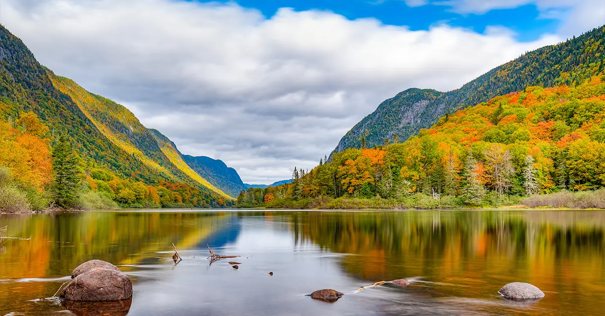
Quebec’s geography is the decisive factor in shaping the economy, culture, population and life of Canada’s largest province. With an area of 1,542,056 km²,Quebecis nearly three times the size of France and ranks 10th among the world’s largest sub-national administrative units. The province stretches from its southern border with the United States all the way to Hudson Bay and the Arctic Ocean, encompassing three of Canada’s main physiographic regions and four climate zones from temperate to Arctic.
This article sets out in detail Quebec’s physical and administrative geography, including its position, boundaries, terrain, river and lake systems, climate, ecosystems and administrative regions. This is foundational information for anyone interested in living, investing or settling in Canada’s most distinctive province.
Message
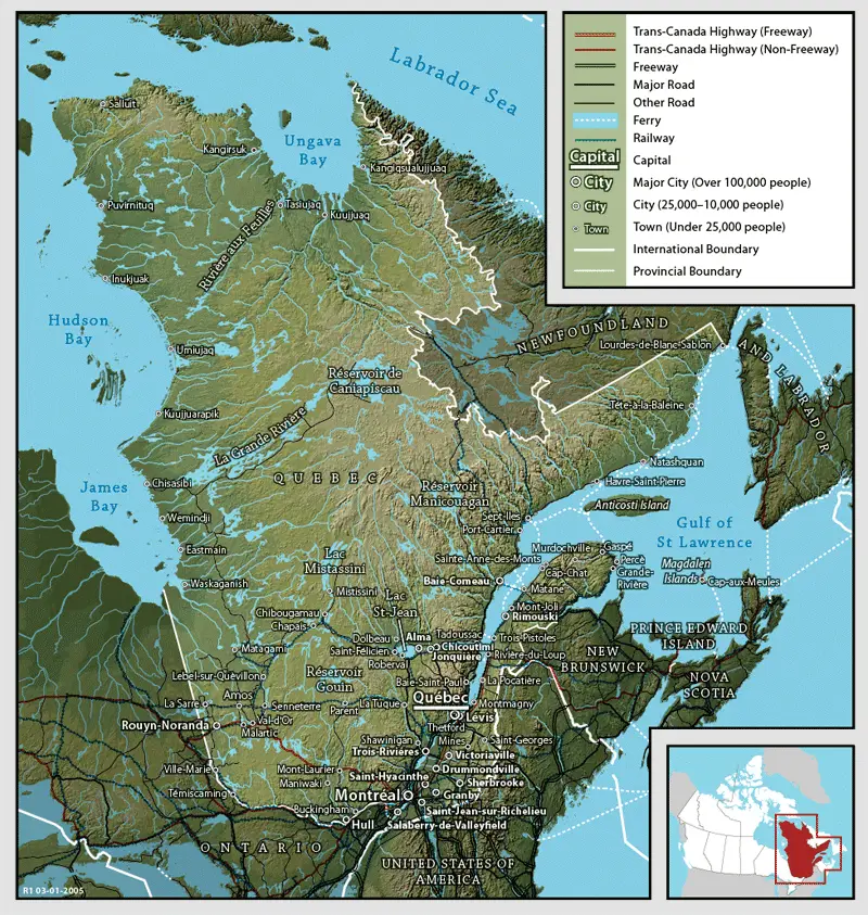
Geographical position and coordinates
Quebec lies in eastern Canada, occupying much of north-eastern North America. The province stretches from latitude 45° to latitude 62° North – a latitudinal range equivalent to the distance from Rome (Italy) to the Arctic Circle.
The capital Quebec City lies at 46°49′ North and 71°13′ West, on the north bank of the St. Lawrence River. Montreal – the province’s largest city – lies at 45°30′ North and 73°34′ West, around 250 km south-west of Quebec City.
Quebec’s geographical position is strategic. The St. Lawrence River is the waterway linking the Atlantic Ocean with the Great Lakes, allowing Quebec to be the trade gateway of north-eastern North America for more than four centuries. The province’s borders run more than 12,000 km – including the longest border with the United States of any Canadian province.
Considering a residency programme? The Prosperous Living Investment team assesses your profile free of charge and advises on the pathway that fits your goals.
Boundaries and area
With an area of 1,542,056 km², Quebec is Canada’s largest province and nearly three times the size of France. By comparison, Quebec is larger than the whole state of Alaska and slightly smaller than Argentina.
Quebec’s main boundaries are:
- To the north: Hudson Strait and Ungava Bay – adjoining the Arctic
- To the east: the province of Newfoundland and Labrador
- To the south-east: the Gulf of St. Lawrence, the state of New Brunswick and the state of Maine (United States)
- To the south: the United States states of New Hampshire, Vermont and New York
- To the west: the province of Ontario and James Bay (part of Hudson Bay)
Despite its vast area, most of Quebec’s territory has a very low population density. More than 90% of the province’s 8.7 million people are concentrated in the St. Lawrence valley in the south – an area accounting for only around 2% of the total territory. The northern regions, particularly above latitude 55°, are almost pristine wilderness with sparse First Nation communities (Cree, Inuit, Innu, Naskapi).
The three main physiographic regions
Theo The Canadian Encyclopedia, Quebec comprises three of Canada’s seven main physiographic regions: the St. Lawrence Lowlands, the Canadian Shield and the Appalachians. Each region has its own geology, landscape and living conditions.
The St. Lawrence Lowlands
The St. Lawrence Lowlands are the smallest but most important physiographic region of Quebec. This region stretches along the St. Lawrence River from the Ontario border to the Charlevoix region, covering around 41,000 km² of the 46,000 km² of the whole St. Lawrence Lowlands.
Notable features:
- Average elevation below 100 metres above sea level
- Fertile sedimentary soil, formed from the bed of the ancient Champlain Sea (present around 14,000 years ago)
- The mildest climate in Quebec
- The province’s largest agricultural production region
The St. Lawrence Lowlands are home to more than 80% of Quebec’s population, including the two largest cities, Montreal and Quebec City, together with important urban centres such as Trois-Rivières, Sherbrooke and Gatineau. This area also accounts for most of the province’s industrial, commercial and service activity.
The plain also has the isolated Monteregian Hills near Montreal – the remnants of volcanic activity around 100 million years ago. The famous hills include Mont Royal (233 metres – Montreal’s emblematic summit) and Mont-Saint-Hilaire.
The Canadian Shield
The Canadian Shield, also known as the Laurentian Shield, covers more than 90% of Quebec’s area. It is one of the world’s oldest rock formations, with some parts more than 4 billion years old – among the oldest rocks ever found on the Earth’s surface.
Geological features:
- Mainly Precambrian granite and gneiss
- Gently rolling hilly terrain, worn down by glaciers during the ice ages
- Thousands of lakes large and small scattered across it – the legacy of the glaciers
- Vast boreal (coniferous) forest
South of the Canadian Shield in Quebec are the Laurentians – the mountain range immediately north of the St. Lawrence valley. This range is a popular tourist destination with ski resorts, lakeside resorts and Mont-Tremblant National Park.
Further north, the Canadian Shield extends up to the Ungava region. Here, the James Bay Hydroelectric Project on the La Grande and Eastmain rivers is one of the largest hydroelectric works in the world, supplying most of Quebec’s electricity and exporting to the United States.
The Appalachians
The Appalachians run from Alabama (United States) up to Quebec’s Gaspé Peninsula. In Quebec, the Appalachians lie on the south bank of the St. Lawrence River, comprising the Estrie (Eastern Townships), Beauce, Bas-Saint-Laurent and Gaspésie regions.
Features:
- Old mountains, long worn down, of moderate height
- Mixed deciduous forest (maple, oak, beech) and coniferous forest
- The highest peak in the Quebec section is Mont Jacques-Cartier (1,268 metres) on the Gaspé Peninsula
- A mild climate, suited to agriculture and forestry
Forillon, Gaspésie and Mont-Mégantic National Parks all lie within Quebec’s Appalachian region. This range is famous for its brilliant autumn scenery as the maple leaves turn red and gold – the reason it attracts millions of visitors each year.
The river and lake systems
Quebec has one of the richest hydrological systems in North America. The province has hundreds of thousands of lakes and more than 4,500 rivers, accounting for around 12% of the world’s renewable fresh water.
The St. Lawrence River
The St. Lawrence River is the most important river in Quebec’s geography and one of the largest waterways in North America. The river runs 3,058 km measured from its source at the Great Lakes, or 1,197 km counting only the “St. Lawrence River” in the narrow sense.
Theo The Canadian Encyclopedia, the St. Lawrence River formed around 10,000 years ago as the glaciers retreated. The river links the Great Lakes with the Atlantic Ocean, forming the east-west transport axis of north-eastern North America.
The St. Lawrence Seaway, completed in 1959, allows large ocean-going ships to travel from Montreal to the port of Duluth (Minnesota, United States) at the western end of the Great Lakes. It is one of the world’s greatest canal engineering works.
At Quebec City, the St. Lawrence River narrows considerably – the reason the city was named “Quebec” from the Algonquin word “kebec” meaning “where the river narrows”.
Other major rivers
Beyond the St. Lawrence, Quebec has many important rivers:
- The Ottawa River: the natural border with Ontario, around 1,270 km long
- The Saguenay River: the main tributary of the St. Lawrence, running through the spectacular Saguenay Fjord
- The Saint-Maurice River: an important industrial river, flowing through Trois-Rivières
- The La Grande River: the main hydroelectric river of the James Bay project
- The Richelieu River: connecting Lake Champlain with the St. Lawrence
Major lakes
Quebec has more than a million lakes of all kinds, many of them only numbered because they have no name. The largest lakes are:
- Lake Mistassini: the largest lake entirely within Quebec, covering 2,335 km²
- Lac Saint-Jean: a large freshwater lake, the source of the Saguenay River
- Lake Champlain: a lake shared with Vermont and New York, United States
- Lake Abitibi: a lake shared with Ontario
Climate
Quebec has an extremely diverse climate because it spans so many latitudes. Under the Köppen classification, Quebec comprises four main climate zones from temperate to Arctic.
The humid continental zone (Dfb)
This is the climate zone of southern and western Quebec, including Montreal, Quebec City, Gatineau, Sherbrooke and most of the populated area. Features:
- Four distinct seasons
- Warm to hot summers, frequently with high humidity (average July temperature: 20–22°C, peaks may exceed 30°C)
- Very cold, snowy winters (average January temperature: -10 to -15°C, and may fall below -25°C)
- Average rainfall of 1,000–1,200 mm a year, of which snow accounts for a significant share
In Montreal, the record high temperature is 37.6°C (summer 1975) and the lowest is -37.8°C (winter 1957). Quebec City is usually around 3–5°C colder than Montreal and receives more snow, with an average snowfall of 300 cm a year.
The subarctic zone (Dfc)
Central Quebec, from latitude 51° to 58°, has a subarctic climate. Features:
- Very long, cold winters (5–8 months)
- Short, cool summers (only 2–3 months)
- Average January temperature of -20 to -30°C
- Less precipitation than in the southern climate zone
The Arctic zone (ET)
North of latitude 58°, particularly the Nunavik region and the Ungava Peninsula, has a true Arctic climate. At Kuujjuaq on Ungava Bay, the average January temperature is -24°C and July reaches only 11°C. This area has permafrost and no trees because the climate is too harsh.
The eastern maritime climate zone
The Gaspé Peninsula and the islands in the Gulf of St. Lawrence have a climate strongly influenced by the sea, with milder winters and cooler summers than inland areas at the same latitude.
Ecosystems and biodiversity
Quebec is one of Canada’s most biodiverse provinces, with four main vegetation zones from north to south.
Temperate broadleaf forest
In the St. Lawrence valley and the southern Appalachians, the forest is mainly deciduous broadleaf: maple, oak, beech, elm and ash. This region is famous for its red autumn foliage and its maple syrup industry (Quebec is the world’s largest producer of maple syrup, accounting for 72% of global output).
Mixed forest
Central Quebec has mixed forest of broadleaf and coniferous trees (pine, spruce, fir). This is a region where forestry and paper production have developed strongly.
Boreal forest (taiga)
From latitude 52° to 56°, Quebec has vast boreal forest of pine, spruce, fir and shrubs. This is home to the caribou herds.
Arctic tundra
North of latitude 56°, the tundra has no trees but only lichen, moss and peat bog. Characteristic animals include the polar bear, the Arctic fox and the Arctic hare.
In total, Quebec has more than 650 bird species, 90 mammal species, 38 reptile and amphibian species, and more than 200 freshwater fish species. The province has 27 national parks and hundreds of nature reserves.
Natural resources
Quebec’s geography provides abundant natural resources:
- Hydroelectricity: Quebec is Canada’s largest producer of hydroelectricity, accounting for around 96% of the province’s electricity output. Hydro-Québec is one of the largest public electricity companies in North America.
- Minerals: iron ore in the Labrador Trough, gold in Abitibi, nickel, copper, zinc, uranium and diamonds
- Forest products: softwood and hardwood, with a forest area of around 760,000 km²
- Fresh water: accounting for 3% of the world’s renewable fresh water
- Siro maple: accounting for 72% of world output
The administrative regions
Quebec is divided into 17 administrative regions (régions administratives) for governance:
- Bas-Saint-Laurent
- Saguenay–Lac-Saint-Jean
- Capitale-Nationale (including Quebec City)
- Mauricie
- Estrie
- Montréal
- Outaouais
- Abitibi-Témiscamingue
- Côte-Nord
- Nord-du-Québec
- Gaspésie–Îles-de-la-Madeleine
- Chaudière-Appalaches
- Laval
- Lanaudière
- Laurentides
- Montérégie
- Centre-du-Québec
Each region has its own economic, population and cultural character, reflecting the province’s vast geographical diversity.
Conclusion
Quebec’s geography is a distinctive combination of many factors: Canada’s largest province at nearly three times the size of France, three main physiographic regions (the St. Lawrence Lowlands, the Canadian Shield and the Appalachians), an enormous river system with the St. Lawrence as its central artery, four climate zones from temperate to Arctic, and abundant natural resources from hydroelectricity to minerals and forest products. It is this geographical diversity that has shaped Quebec’s distinctive economic structure, population and culture over four centuries.
Understanding Quebec’s geography helps grasp why the province’s population is concentrated mainly in the St. Lawrence valley, why hydroelectricity is the energy mainstay and why industries such as aerospace, mining and forestry have developed so strongly.
Accompanying you on your journey in residency investment
The Prosperous Living Investment team advises on pathways, assesses profiles and manages investments transparently for every residency, citizenship and international property objective.
Free profile assessmentWhere life gets prosperous