

Latvian geography has the character of a Northern European coastal country, with an area of 64,573 km², flat terrain and varied ecosystems. The countryLatvialies on the eastern shore of the Baltic Sea, forming a natural bridge between Northern and Eastern Europe, and is one of the three Baltic states alongside Estonia and Lithuania.
The country has more than 12,000 rivers, more than 2,200 natural lakes and forest cover reaching 54% — among the highest in the European Union. This article sets out Latvian geography systematically across 6 main aspects: position and borders, the 5 geographical regions, the river system, the climate, natural resources, and the network of 4 national parks.
Message
Position and borders in Latvian geography
Latvian geography places the country in Northern Europe, at latitudes from 55°40′ to 58°05′ North and longitudes from 20°58′ to 28°14′ East. This position puts Latvia on a level with cities such as Copenhagen (Denmark), Edinburgh (Scotland) and Moscow (Russia), explaining the region’s long winters and short summers.
Latvia has 4 land neighbours and one across the sea. The border with Lithuania to the south runs 588 km, with Estonia to the north 343 km, with Russia to the east 276 km and with Belarus to the south-east 161 km. The total land border runs around 1,368 km.
The Baltic coastline running along the west and north of Latvia totals 498 km, comprising the Gulf of Riga and the open Baltic. The Gulf of Riga is a relatively enclosed shallow body of water, separated from the open Baltic by Estonia’s island of Saaremaa. Across the Baltic, Latvia has a maritime border with Sweden to the north-west, opening trade routes to Stockholm and the other Nordic countries.
Latvia’s total area is 64,573 km², ranking 124th in the world. The country is larger than several EU members such as the Netherlands, Belgium, Denmark, Switzerland and Estonia. With its shape elongated east to west, the greatest distance from the easternmost to the westernmost point is 449 km, while from north to south it is 210 km.
Considering a residency programme? The Prosperous Living Investment team assesses your profile free of charge and advises on the pathway that fits your goals.
Latvian geography through its 5 cultural and topographical regions
Latvian geography divides the country into 5 traditional cultural and geographical regions, each with its own terrain, history and cultural identity. This division reflects Latvia’s long history and geographical variety.
The Vidzeme region lies in the north and north-east and is the highest area in Latvian geography, with the Vidzeme Upland. Gaiziņkalns at 311.6 metres — the country’s highest point — lies in this region. Vidzeme accounts for around a third of the national area and has the richest system of hills, lakes and forests.
The Latgale region in the south-east, bordering Russia and Belarus, is known as “the land of blue lakes” for its more than 1,000 natural lakes. The Kurzeme region in the west has a long Baltic coastline and important ports such as Liepāja and Ventspils. The Zemgale region in the south-centre is a fertile agricultural plain, regarded as Latvia’s breadbasket. The Riga region is in the centre, around the capital and the Gulf of Riga.
A common feature of Latvian geography is relatively flat terrain, formed mainly by the action of meltwater at the end of the last ice age. Around 57% of the territory lies below 100 metres above sea level. The coastal lowlands and the Daugava basin are interspersed with glacial hill ridges 100–300 metres high. The west coast has dunes and low sea cliffs, while the shore of the Gulf of Riga is mostly gently sloping sand.
The river, lake and Baltic Sea system
The hydrological system is one of the most notable features of Latvian geography, with more than 12,000 rivers and more than 2,256 natural lakes above 1 hectare in area. River density is among the highest in Europe, reflecting the post-glacial geology of the Baltic region.
The Daugava is the most important river in Latvian geography, running 367 km within the country of its total 1,020 km (rising in Russia’s Tver region and flowing through Belarus before entering Latvia). The Daugava flows into the Gulf of Riga, passing through the capital, and was the historic waterway linking the Baltic with the Volga network and Constantinople. Today, the Daugava supplies around 70% of national hydroelectric output through the Pļaviņas, Ķegums and Riga power stations.
The Gauja is the longest river lying entirely within Latvia, at 460 km. It rises and ends within the country, flowing through the Vidzeme Upland and forming the Gauja valley up to 85 metres deep — spectacular terrain, rare in a Latvian geography otherwise known for its flatness. The other major rivers comprise the Lielupe (119 km), the Venta (178 km within Latvia) and the Salaca (95 km).
The natural lake system is likewise rich, concentrated mainly in the Latgale region in the east. Lake Lubāns is the largest in area at 80.7 km² but only a few metres deep. Lake Rāzna is second in area (57.8 km²) but first in water volume. Lake Drīdzis in Latgale is the deepest at 65.1 metres.
The Baltic Sea and the Gulf of Riga play an important ecological and economic role in Latvian geography. These waters have low salinity (5–8 ppt) because of the large volume of fresh water flowing in from the rivers and their relative isolation from the North Atlantic. The Baltic marine ecosystem is distinctive, with characteristic fish such as Baltic herring, Baltic sprat and cod. According to theLatvian Nature Conservation Agency, many coastal and offshore areas have been brought into the marine protected area system to protect Baltic biodiversity — an important element of coastal Latvian geography.
Climate and weather in Latvian geography
The climate is a key factor in Latvian geography, affecting agriculture, daily life and tourism. Latvia has a temperate climate transitional between maritime on the western coast and continental in the east further inland. This transition creates a marked temperature range between regions despite the country’s small area.
Latvian winters run from late November to early April, with average January temperatures ranging from -2°C on the coast to -7°C in Latgale in the east. Snow lies on average 80–120 days a year, with depths regularly reaching 20–50 cm inland. Temperatures below -25°C have been recorded in severe cold spells.
Summer runs from June to August with average July temperatures of 16 to 18°C. Extreme heatwaves may push temperatures above 30°C for a few days, although this is relatively rare. Spring and autumn are two short transitional seasons, marked by drizzle, fog and sharply fluctuating temperatures.
Average annual rainfall nationwide is 600–700 mm, fairly evenly distributed through the year with a peak in July and August. The Vidzeme uplands receive more — up to 800 mm — through the effect of the terrain. Average annual sunshine is around 1,700–1,900 hours, considerably less than in Southern Europe but on a par with the other Nordic countries.
Climate change is visibly affecting Latvian geography. According to the Latvian Environment, Geology and Meteorology Centre (LVGMC), the average annual temperature rose by around 1.3°C over 1961–2020. Winters show signs of becoming milder, summers longer, and extreme weather events such as heavy rain and spring flooding are increasingly common — changes that are reshaping Latvian geography over the long term.
Natural resources and forests in Latvian geography
Forests are the most important natural asset in the structure of Latvian geography. Forest covers around 54% of the country’s total area, placing it in the top 5 for forest cover in the European Union after Finland, Sweden, Slovenia and Estonia. Forest area has grown considerably over the 20th century through reduced agricultural activity and reforestation programmes.
The main tree species in Latvian forests comprise Scots pine (Pinus sylvestris) at 35% of the forest area, Norway spruce (Picea abies) at around 18% and silver birch (Betula pendula) at around 30%. The remainder comprises aspen, oak, rowan and other broadleaf species. Forestry contributes around 5–6% of GDP and is one of the spearhead export sectors, with timber, paper and furniture products accounting for a high share of total export earnings.
Latvia’s mineral resources are relatively limited. The country has no oil, no commercial gas and no significant precious metals. The minerals of economic significance comprise dolomite, limestone, clay, quartz sand, gravel and peat. Baltic amber — the region’s traditional speciality — is still gathered on a small scale along the coast and is the raw material for the craft industry.
Abundant fresh water reserves are another notable strength of Latvian geography. Total annual renewable water resources are around 35.2 km³, of which only a small part is used for industry and domestic supply. Groundwater and surface water quality is generally good, meeting EU drinking water standards in most areas. The Baltic fishery resources of herring, sprat, cod and salmon also contribute importantly to the food and export sectors.
Agricultural land accounts for around 28% of the country in the structure of Latvian geography, concentrated in Zemgale and part of Vidzeme. Podzolic soils and river alluvium are the main soil types, suited to cereals, potatoes, field crops and livestock. Although the growing season is short, agricultural productivity has risen considerably through mechanisation and the adoption of EU technology since 2004.
National parks and reserves in Latvian geography
The system of protected areas is a notable achievement in managing Latvian geography. As at the beginning of 2025, the country has 760 specially protected areas, 4 national parks, 4 strict nature reserves and many nature parks and protected landscape areas. Most of these are integrated into the EU’s Natura 2000 network following Latvia’s accession in 2004.
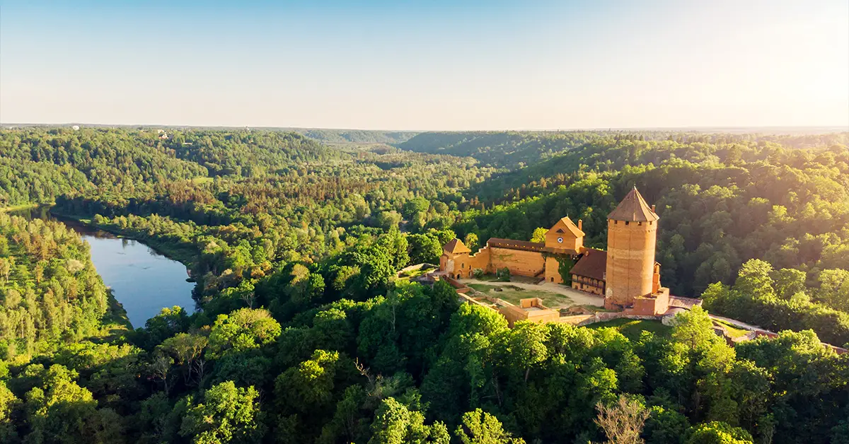
Gauja National Park is the oldest and largest, established in 1973 covering 91,745 hectares in the Vidzeme region. It is known as “the Switzerland of Latvia” for the Gauja valley with its sandstone cliffs up to 22 metres high, its cave system formed in the Devonian period (370 million years ago), and more than 500 cultural and historical monuments comprising the castles of Turaida, Cēsis and Sigulda. The fauna is varied with 48 mammal species and 149 bird species, comprising the Eurasian lynx, the grey wolf and the beaver.
Ķemeri National Park west of Riga was established in 1997 covering 38,165 hectares and is the third largest national park. Its outstanding feature is the Great Ķemeri Bog (Lielais Ķemeru tīrelis) — one of Latvia’s largest raised bogs, with a distinctive ecosystem and rare birds such as the common crane and the white-tailed eagle. The area is also known for its mineral springs and therapeutic mud, around which spa resorts grew up from the 19th century.
Slītere National Park at the northern tip of Kurzeme was established in 2000 on the basis of a reserve dating from 1923. The park protects the “Blue Hills” formed by glacial meltwater, the traditional Livonian fishing villages and Cape Kolka — where the Gulf of Riga meets the open Baltic. Baltic grey seals and ringed seals can be seen along the coast. The Slītere lighthouse, built in 1849, is the second tallest and second oldest in Latvia.
Rāzna National Park was established in 2007 covering 59,615 hectares in the Latgale region, and is the newest and second largest. The area is known as “the land of blue lakes”, with Lake Rāzna — Latvia’s second largest. The characteristic landscape comprises wooded hills interspersed with lakes, golden wheat fields and traditional Latgale farmsteads. Its biodiversity comprises beavers, otters, cranes and white-tailed eagles.
Besides the 4 national parks, the protected area network also comprises the North Vidzeme Biosphere Reserve — Latvia’s only biosphere reserve, recognised by UNESCO in 1997. It covers 457,800 hectares, protecting old-growth forest, bog and river ecosystems. Nature parks such as Abava Valley, Pape and Engure also play an important role in protecting biodiversity and developing sustainable eco-tourism.
A summary of Latvian geography
Latvian geography reflects the character of a Baltic country small in area but rich in natural resources. Its position on the Baltic coast brings both trading advantages and geopolitical significance, while the flat terrain and rich river and lake system create conditions for agriculture, forestry and eco-tourism to develop.
Forest cover of 54% and a network of 4 national parks are evidence of the country’s conservation commitment, and also the foundation for a green economy and nature tourism. A temperate climate with long winters and short summers has shaped Latvian ways of living, architecture and culture over centuries. Against the background of climate change, Latvian geography continues to be a key factor in shaping sustainable development policy and protecting resources for future generations.
Accompanying you on your journey in residency investment
The Prosperous Living Investment team advises on pathways, assesses profiles and manages investments transparently for every residency, citizenship and international property objective.
Free profile assessmentWhere life gets prosperous