


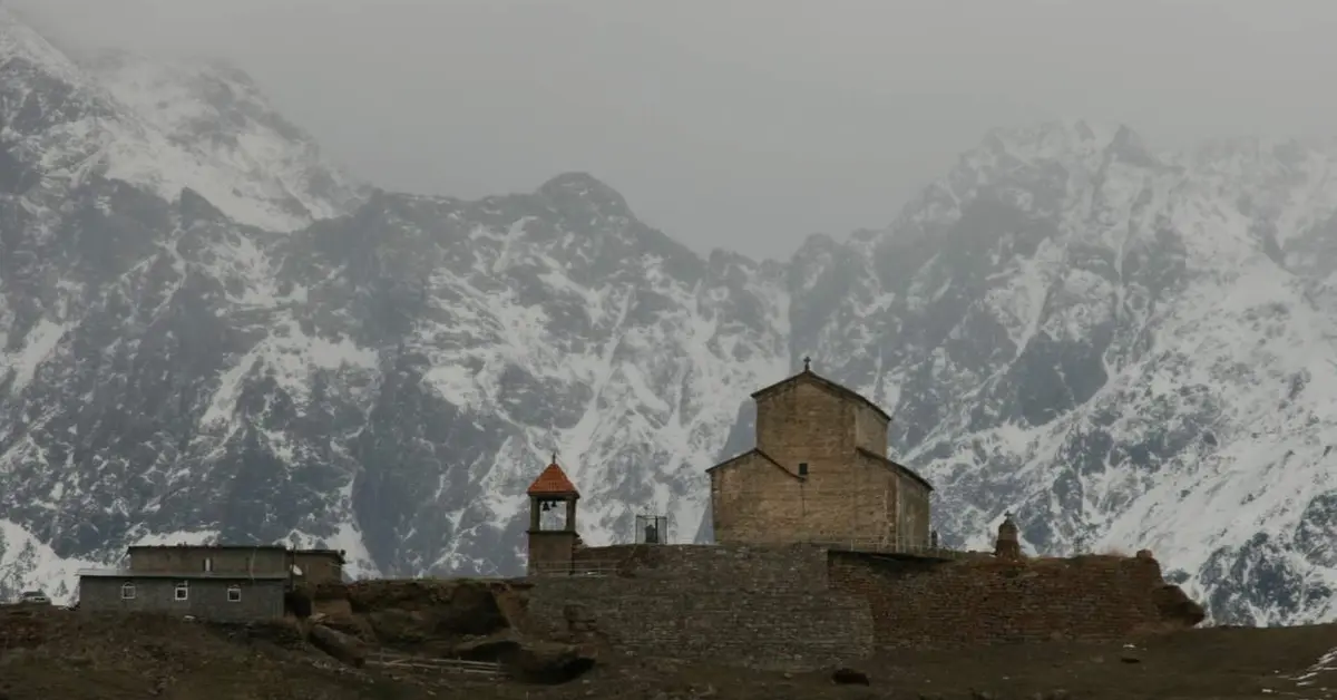
The geography of Georgia reflects a country located at the intersection of Europe and Asia, belonging to the Caucasus region. The study of Georgia’s geography shows that mountainous terrain predominates, sandwiched between the Black Sea to the west and high mountain ranges to both the north and south, creating extremely diverse landscapes and climates.
Contents
Overview of the Geography of Georgia
To understand the geography of Georgia, one must first picture a small country packed with many terrain types. This country lies entirely within the Caucasus region, extending in an east-west direction between the Black Sea and high mountain ranges. In a narrow space, the landscape can shift rapidly from a warm coastline to snow-capped peaks.
A striking feature of Georgia’s geography is the interweaving of mountains and valleys. Two major mountain ranges embrace the central depression, where most of the population and urban areas are concentrated. Thanks to this, the country possesses both rugged terrain and lowlands favourable for farming.
Alongside the terrain, the crossroad location between two continents also shapes the nation’s identity. Georgia serves as an East-West connecting corridor, as well as a meeting point for numerous cultural streams. These characteristics lay the foundation for the detailed exploration of borders, mountains, rivers and climate that follows.
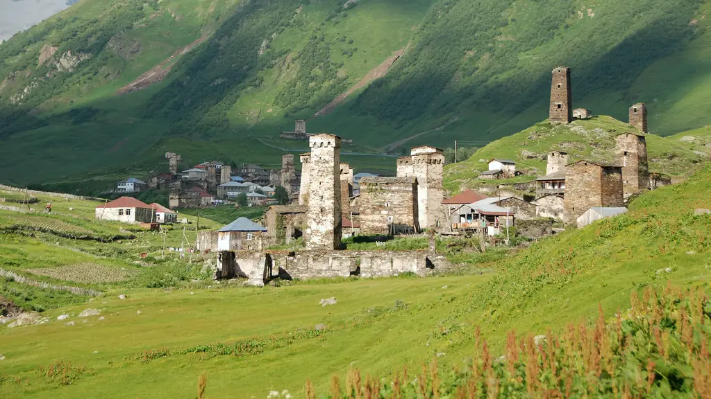
The Caucasus mountains and Svaneti towers represent the geography of Georgia.
Considering a residency programme? The Prosperous Living Investment team assesses your profile free of charge and advises on the pathway that fits your goals.
Geographical Location and Borders of Georgia
Georgia is situated in the Caucasus region, which is often regarded as the natural boundary between Europe and Asia. This country lies on the eastern shore of the Black Sea, with most of its territory stretching across mountain slopes and valleys. That transit location has shaped the history, trade and cultural identity of the country of Georgia over the centuries.
Regarding borders, Georgia is bordered by Russia to the north along the Greater Caucasus range. To the south, the country borders Turkey and Armenia, while Azerbaijan lies to the southeast. The west opens up to the Black Sea, giving Georgia a coastline of strategic value.
Its location bordering multiple countries makes Georgia an important connecting corridor. Roadways and energy pipelines passing through this territory link the Caspian Sea region with Europe. This characteristic brings both opportunities and geopolitical challenges to the country.
- North: bordered by Russia along the Greater Caucasus range.
- South: bordered by Turkey and Armenia.
- Southeast: bordered by Azerbaijan.
- West: opens to the Black Sea.
Area and General Territorial Characteristics
When examining Georgia’s geography, the territorial area is approximately 69,700 km², a relatively modest figure compared to its large neighbours. Although not vast, this country contains considerable topographical diversity, from coastal plains to year-round snow-capped peaks. It is this compactness that creates the distinctive landscape here.
Georgian territory stretches in an east-west direction, with its western part facing the Black Sea and its eastern part retreating deep inland. Two major mountain ranges run almost parallel, embracing the central depression. This structure divides the country into multiple sub-regions with distinctly different natural conditions.
Most of the territory is mountainous, while lowlands are concentrated along river valleys and the coast. The large elevation difference within a narrow range causes living, farming and transport conditions to change rapidly between regions. This characteristic deeply affects population distribution and economic activities.
The Greater Caucasus and Lesser Caucasus Ranges
Two major mountain systems define the topographical framework of Georgia. The Greater Caucasus range runs along the northern border, acting as a natural wall that separates the country from Russia. This is a high, rugged mountain region with many ice-capped peaks and permanent glaciers.
To the south, the Lesser Caucasus range has a lower elevation but still creates a landscape of plateaus and medium-height mountains. Between the two ranges lies the central depression, where the majority of the population and arable land are concentrated. This sandwiched structure is the core topographical feature of the country.
The mountain ranges not only shape the landscape but also dictate the climate and hydrology. They block air masses, creating a clear distinction in rainfall and sunshine between the slopes. Consequently, Georgia possesses many different ecological zones within a relatively narrow geographical space.
Mount Shkhara and High Mountain Regions
Among Georgia’s peaks, Shkhara is often cited as the country’s highest point, located in the Greater Caucasus range near the northern border. This area has an elevation exceeding 5,000 m and is covered in ice and snow year-round. The high mountain landscape here possesses the majestic and harsh characteristics typical of the Caucasus region.
The high mountain region of Georgia is also notable for Svaneti, a historical area located deep within the Greater Caucasus range. Svaneti is famous for its ancient stone towers and villages isolated amidst icy valleys. The rugged natural conditions have helped this place preserve many long-standing traditional cultural features.
The high mountain regions play a crucial role in the country’s water resources and biodiversity. Melting snow and glaciers provide water for many major rivers. At the same time, the rugged terrain limits transport and causes some areas to become almost completely isolated during winter.
The Kolkheti Plain and Lowland Regions
Beyond the mountains, Georgia’s geography also features important lowlands in the west. The Kolkheti Plain, located along the Black Sea, is one of the lowest and wettest areas in the country. It receives abundant rainfall from moist air masses blowing in from the sea, creating a characteristic landscape of wetlands and dense forests.
This plain is associated with the lower reaches of the Rioni River and many small streams flowing into the sea. Fertile soil and a warm climate make Kolkheti favourable for cultivating subtropical crops. Historically, this land is often mentioned as one of the oldest agricultural cradles of the Caucasus region.
Conversely, the lowlands in the east around the Kura River valley are drier and warmer. The contrast between the humid western plains and the dry eastern depression clearly reflects the territorial differentiation. These lowlands, although not large in area, concentrate a significant portion of the population and production activities.
River Systems: Kura and Rioni
Georgia’s river network is directly influenced by the mountainous terrain. The Kura River, also known as Mtkvari in Georgian, is the most important river flowing through the eastern part of the country. This river passes through the capital, Tbilisi, and plays an essential role in agriculture and the lives of the residents.
In the west, the Rioni River is the primary waterway, originating from the Greater Caucasus range and flowing into the Black Sea. The Rioni basin lies in a more humid climate zone, supporting diverse cultivation and rich vegetation. The two river systems, Kura and Rioni, clearly reflect the east-west differentiation of the country.
Rivers in Georgia are mostly steep and fast-flowing due to the significant elevation difference. This feature creates considerable potential for hydropower, an important energy source for the country. Furthermore, river valleys are also where population and agricultural activities are concentrated.
Besides the two main rivers, Georgia also has many lakes scattered throughout, mostly in the mountains and plateaus. Some lakes were formed by tectonic or glacial activity, contributing to the regulation of local water sources. Together with rivers and streams, the lake system creates a diverse hydrological network spread across the territory.
Diverse Climates from Subtropical to Alpine
Climate is one of the most prominent aspects when exploring the geography of Georgia. The Black Sea coast in the west features a humid subtropical climate, with mild winters and abundant rainfall. These conditions are favourable for growing crops such as tea, citrus fruits, and many other subtropical plants.
As one moves deeper into the east and higher in elevation, the climate becomes drier and more continental. The eastern depression around Tbilisi has hot summers and relatively cold winters. In the high mountain regions, the climate shifts to an alpine type with prolonged snow cover and low temperatures year-round.
The differentiation of climate by elevation and east-west orientation creates many different ecological zones. Within a relatively narrow range, Georgia can transition from a subtropical landscape to alpine meadows and ice and snow. This is one of the reasons why this country has such rich flora and fauna.
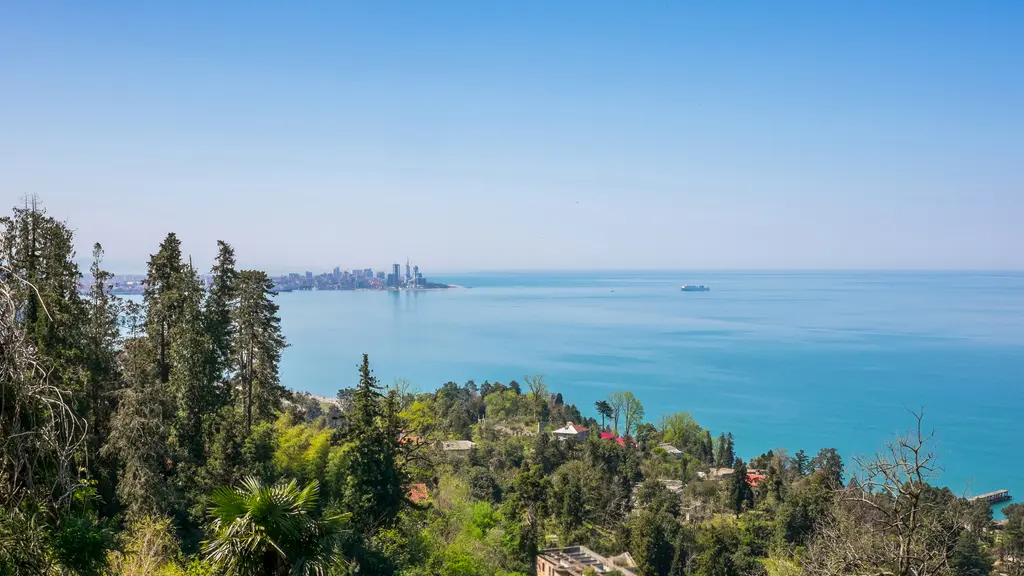
The Black Sea coast in the west is an important part of Georgia’s geography.
Biodiversity and Forests
The differentiation of terrain and climate is the foundation for Georgia’s high level of biodiversity. Within a small area, this country can transition from humid subtropical coastal forests to alpine coniferous forests and mountain meadows. Each ecological zone nurtures different populations of flora and fauna, creating a rich natural picture.
Forests occupy a significant portion of the territory, especially on the slopes of the Greater Caucasus and Lesser Caucasus ranges. These forests not only play an ecological role but also contribute to soil protection and flow regulation. Thanks to the rugged terrain, many forests have remained relatively intact.
To preserve the landscape and organisms, Georgia maintains many protected areas and national parks. These areas stretch from coastal wetlands to mountain forests and high meadows. The preservation of biodiversity is closely linked to the specific natural characteristics of each geographical region in the country.
Representative Geographical Regions: Svaneti and Kakheti
Georgia is divided into many historical-geographical regions with their own distinct identities. Svaneti, located in the northwest within the Greater Caucasus range, is a typical high mountain region with deep valleys and snow-capped peaks. The rugged terrain makes this place both isolated and able to retain unique ancient cultural features.
In the east, Kakheti is a region of plains and low hills famous for its farming traditions. The drier, warmer climate and fertile soil make Kakheti an important agricultural hub. This region is associated with long-standing cultivation activities and is an essential part of the agricultural economic picture.
Besides Svaneti and Kakheti, Georgia has many other notable geographical regions. Adjara in the southwest lies along the Black Sea, featuring a humid subtropical climate and hilly terrain close to the sea. Samegrelo in the west stretches across the Kolkheti lowlands, where rivers are dense and fields are fertile.
The differences between the regions clearly illustrate the geographical diversity of the country. On one side are cold, high mountains; on the other are warm, fertile plains; and there is also a humid coastal strip. It is this contrast that creates the rich natural picture spread across Georgia’s territory.
Administrative Zoning by Geographical Characteristics
The administrative organisation of Georgia partly reflects its natural geographical characteristics. The territory is divided into many regions and lower-level units, where boundaries often follow river valleys, mountain ranges, or long-standing historical areas. Consequently, many administrative units coincide with familiar natural sub-regions.
The capital, Tbilisi, is located by the Kura River in the east, serving as the political and residential centre of the country. Surrounding it are regions such as Kakheti, Imereti, and Samegrelo, each associated with its own terrain and climate conditions. This distribution shows the close connection between geography and spatial organisation.
Geographical zoning also helps in managing resources and developing in a way that is appropriate for each area. The high mountain region focuses on livestock, forestry, and tourism, while the plains concentrate on cultivation and urbanisation. This approach reflects the reality that nature shapes how humans organise their lives.
Natural Disasters: Earthquakes and Landslides
Located in the Caucasus region with complex tectonic activity, Georgia faces a certain risk of earthquakes. The collision between tectonic plates in the area makes the local geology not entirely stable. Earthquakes, regardless of their magnitude, are a natural feature that the country must take into account.
In addition to earthquakes, the steep terrain and heavy rainfall in many areas increase the risk of landslides. On the slopes of the Greater Caucasus range, landslides and mudflows can occur, particularly during the rainy season or when snow melts. These phenomena affect transport and highland settlements.
Therefore, understanding natural disaster risks is an important part of studying the country’s geography. Construction, transport and residential planning often have to take geological characteristics and slope gradients into account. The link between terrain and natural disasters shows that nature is both generous and challenging.
Abkhazia and South Ossetia Geographically
From a geographical perspective, the two regions of Abkhazia and South Ossetia occupy notable locations and landscapes within the country’s overall territory. Abkhazia lies in the north-western corner, along the Black Sea and adjacent to the Greater Caucasus range, featuring a humid subtropical climate and a landscape combining coast and mountains. This region possesses particularly rich natural assets.
South Ossetia lies further inland, on the southern slopes of the Greater Caucasus range. This region is predominantly mountainous and valley terrain, with a climate clearly influenced by altitude. In terms of location, it is situated in the north-central part of the territory, close to the northern border.
On maps, these two areas are considered territories belonging to Georgia, although the on-the-ground situation involves specific issues outside the scope of physical geography. Within the framework of this article, the focus is on terrain, climate and landscape characteristics. Both regions further illustrate the country’s natural diversity.
Natural Resources and Economic Impact
Geographical characteristics directly govern Georgia’s resources. The steep river system and abundant rainfall in the west create great potential for hydroelectricity, an energy strength of the country. Besides, the fertile soil in the valleys and plains supports diverse agriculture.
Water resources are one of the prominent strengths associated with the mountainous terrain. Numerous and steep rivers and streams help Georgia develop hydroelectric projects while providing water for domestic use and irrigation. The rational exploitation of water resources is considered an important direction for sustainable development.
Mineral resources and natural landscapes also contribute significantly to economic activity. The mountainous and coastal regions attract tourism, while the trans-Caucasus transport routes reinforce its transit role. These factors are closely tied to the picture the Georgian economy modern.
The uneven distribution of resources according to terrain also shapes how the population lives and works. The lower riverine regions concentrate farming and urban areas, while the high mountains focus on livestock farming and tourism. The connection between geography and livelihoods is clearly reflected in demographics of Georgia.
According to statistical agencies and international organisations, natural characteristics are the foundation for the country’s long-term development orientation. Official data on population, economy and resources can be consulted via the National Statistics Office of Georgia (Geostat) (https://www.geostat.ge/en) and the World Bank – Georgia (https://www.worldbank.org/en/country/georgia).
Where is Georgia located on the world map?
Georgia is a country in the Caucasus, situated at the junction of Europe and Asia. It borders the Black Sea to the west, Russia to the north, Türkiye and Armenia to the south, and Azerbaijan to the south-east.
What is the area of Georgia?
Georgia's territory covers approximately 69,700 km², relatively small compared with its larger neighbours. Despite its modest size, the country has highly varied terrain, from coastal plains to high mountain peaks capped with snow year-round.
Which is the highest peak in Georgia?
Shkhara is generally regarded as Georgia's highest peak, located on the Greater Caucasus range near the northern border, at an elevation of over 5,000 m. The area is covered in snow and ice year-round, with the majestic high-mountain scenery characteristic of the Caucasus region.
What are the notable features of Georgia's climate?
Georgia's climate varies greatly with altitude and terrain. The Black Sea coast has a humid subtropical climate, while the east is drier and more continental. The high mountain areas are cold, with prolonged snow cover and low temperatures year-round.
What are Georgia's two largest rivers?
The two most important rivers are the Kura (Mtkvari), which flows through the eastern part of the country and through the capital Tbilisi, and the Rioni in the west, which empties into the Black Sea. Both clearly reflect the east–west geographical divide and play a major role in agriculture and hydropower.
Where is the Kolkheti Plain and what makes it special?
The Kolkheti Plain lies in western Georgia, along the Black Sea, and is a low-lying, humid area with abundant rainfall. The region is linked to the lower reaches of the Rioni River, with fertile soil and wetland landscapes favourable for subtropical crop cultivation.
Accompanying you on your journey in residency investment
The Prosperous Living Investment team advises on pathways, assesses profiles and manages investments transparently for every residency, citizenship and international property objective.
Free profile assessmentWhere life gets prosperous