

Geography of Antigua and Barbuda

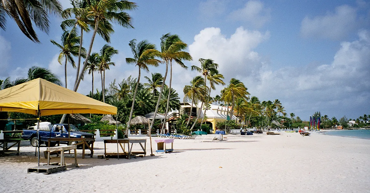
The geography of Antigua and Barbuda is shaped by its location in the Eastern Caribbean and its archipelagic structure of two main islands plus many small dependent islands. The country’s total land area is about 442 km², of which Antigua accounts for about 281 km² and Barbuda 161 km². Redonda — an uninhabited volcanic rock — and many other small islands are scattered around the two main islands.
The two islands have quite contrasting terrain. Antigua is relatively varied, with a small range of hills in the southwest, while Barbuda consists mainly of low-lying wetlands and grassland. Both islands share a tropical savanna climate, an indented coastline with many bays and sandy beaches, and a scarcity of fresh water — a factor that greatly affects the country’s life and economy. This article analyses the main geographical features of Antigua and Barbuda in detail.
Detailed article onthe country of Antigua and Barbuda.
Message
Location
Antigua and Barbuda lies at approximately 17°03′ N and 61°48′ W, in the Leeward Islands — the northern part of the Lesser Antilles. The country sits between the Caribbean Sea to the west and the Atlantic Ocean to the east. Distances to neighbouring countries are relatively short by regional standards: 720 km east of the Dominican Republic, 720 km north of Trinidad and Tobago, and about 30 km between the two main islands of Antigua and Barbuda.
The country’s maritime boundaries adjoin several neighbouring Caribbean countries and territories. Anguilla and Saint Barthélemy lie to the northwest. Saint Kitts and Nevis lies to the west. Montserrat lies to the southwest. Guadeloupe — an overseas region of France — lies directly to the south. This location places Antigua and Barbuda at the centre of the Leeward Islands chain, well placed for trade in the Eastern Caribbean.
Antigua is almost round, with a maximum length of about 22 km and a maximum width of about 18 km. Barbuda is elongated, about 32 km long from north to south. Redonda — a sheer volcanic rock 296 m high — lies about 56 km southwest of Antigua; it is uninhabited and protected as a nature reserve. Several other small inhabited islands are scattered along Antigua’s northeast coast.
Considering a residency programme? The Prosperous Living Investment team assesses your profile free of charge and advises on the pathway that fits your goals.
Terrain and geology
Geologically, the geography of Antigua and Barbuda results mainly from limestone formation and partly from ancient volcanic activity. Both islands are low-lying, unlike some other Caribbean islands with active volcanoes or high mountain ranges. This creates a characteristic landscape of broad plains, traditional farmland and long, flat coastlines.
Antigua
Antigua can be divided into three main terrain zones. The northeast and northwest consist of limestone formations that create karst terrain with caves and shallow sinkholes. The centre is a clay plain, relatively flat, stretching from Saint John’s to English Harbour. The southwest is an ancient volcanic area with steep hills.
Antigua’s highest point is Boggy Peak, at 402 m above sea level, in the Shekerley Mountains. The peak is the remnant of an ancient volcanic crater. In 2009, Prime Minister Baldwin Spencer renamed it Mount Obama in honour of US President Barack Obama. The new name was controversial, and in 2016 the succeeding government restored the name Boggy Peak. The Shekerley Mountains have several other peaks above 300 m and are designated as a national park and nature reserve.
Antigua’s coastline is long and indented, with many deep bays and white sand beaches. Saint John’s has a deep-water harbour able to receive large cruise ships. Other natural harbours such as Parham, English Harbour and Falmouth Harbour offer safe anchorage. English Harbour is especially famous for Nelson’s Dockyard — a UNESCO World Heritage Site — and is the yachting hub of the Eastern Caribbean.
Barbuda
Barbuda is made entirely of limestone and coral sediment, with no volcanic activity. The terrain is very flat, with its highest point reaching only about 44.5 m in the Highlands area east of Codrington. The Highlands are a low plateau with distinctive limestone cliffs, creating a landscape that contrasts with the rest of the island.
Barbuda’s most striking geographical feature is Codrington Lagoon — a brackish lagoon stretching along almost the entire west side of the island. The lagoon is the breeding ground of one of the largest colonies of Magnificent Frigatebirds in the Western Hemisphere, estimated at about 5,000 birds. The Codrington Lagoon Bird Sanctuary is one of the country’s most important eco-tourism sites.
Barbuda’s coastline is surrounded by coral reefs and unique pink sand beaches formed from a mixture of crushed shells and coral. Pink Sand Beach is one of the most famous, stretching more than 17 km along the west coast. The island has only one village, Codrington — home to almost the entire population of Barbuda.
Climate
Antigua and Barbuda has a tropical savanna climate (Köppen Aw), with stable temperatures year-round and a clear distinction between dry and wet seasons. The average temperature is about 25°C in January and about 28°C in August. Summer highs can reach 32°C, rarely exceeding this thanks to the northeast trade winds.
Average annual rainfall is only about 1,000 mm, low compared with many other Caribbean island nations at the same latitude. Antigua is considered one of the sunniest islands in the Eastern Caribbean, with more than 300 sunny days a year. The dry season runs from December to April, coinciding with the peak tourist season. The rainy season runs from June to November, peaking in September and October.
The Atlantic hurricane season from June to November is the biggest risk factor for the geography of Antigua and Barbuda. The country lies in the “hurricane belt” and has suffered considerable damage historically. Hurricane Luis in 1995 caused severe damage on Barbuda. Hurricane Irma in September 2017 — one of the strongest Atlantic hurricanes ever recorded, with gusts above 295 km/h — flattened more than 90% of the buildings on Barbuda and forced the island’s entire population to evacuate to Antigua for months.
According to data published on the official website of theGovernment of Antigua and Barbuda, climate change has been identified as an existential threat to the country. Rising sea levels threaten low-lying coastal areas, especially Codrington on Barbuda. The frequency and intensity of hurricanes are expected to increase under climate scenarios over the coming decades.
Water resources and scarcity
Fresh water is one of the biggest challenges for the geography of Antigua and Barbuda. Both islands have almost no rivers and very few natural streams. Low rainfall, unevenly distributed across the months, makes the water shortage worse. Periodic droughts have affected agriculture and daily life from the colonial era to the present day.
Man-made reservoirs and rooftop rainwater collection are the traditional methods. Large reservoirs such as Potworks Dam, Bethesda Dam and Wallings Dam supply part of Antigua’s fresh water. However, their capacity is not enough to meet demand in severe drought years. Some large hotels and resorts have invested in their own seawater desalination systems using reverse osmosis technology.
Deforestation to expand sugar cane cultivation during the colonial era worsened the water problem. Rainwater runs off too quickly to seep into underground aquifers, leaving the island dependent on increasingly precarious supplies. Reforestation and watershed conservation programmes are under way, but recovery is slow. The country is a party to the United Nations Convention to Combat Desertification (UNCCD) — reflecting the seriousness of the problem.
Flora, fauna and environment
Antigua and Barbuda falls within two distinct ecoregions as classified by the World Wide Fund for Nature (WWF): Leeward Islands moist forests and Leeward Islands xeric scrub. These two ecoregions reflect the environmental contrast between the wetter areas of southwestern Antigua and the drier areas elsewhere.
Native vegetation consists mainly of tropical dry forest with cacti, thorny shrubs and savanna grasses. Characteristic trees include West Indian mahogany, lignum vitae (a sacred hardwood recognised as the national tree), white cedar and the bay tree. Mangroves grow along lagoons and estuaries, and are especially abundant in Codrington Lagoon.
Native fauna is fairly limited because of the islands’ small size and lack of connection to the mainland. Seabirds and migratory birds are the most diverse, including frigatebirds, gulls, pelicans and many species of dove. The Antiguan racer (Alsophis antiguae) is an endemic non-venomous snake assessed as critically endangered. According to data from the International Union for Conservation of Nature (IUCN), its population once fell below 50 individuals in the 1990s before conservation programmes gradually raised numbers to several hundred.
The waters around the two islands have diverse coral reef ecosystems, home to many species of tropical fish, sea turtles and crustaceans. Marine protected areas include the North-East Marine Management Area and Cades Reef Marine Park. Pressure from tourism, pollution and climate change seriously threatens the reefs — especially through coral bleaching, which has become more frequent since the 2010s.
Administrative divisions
Antigua is divided into 6 parishes — administrative units inherited from British colonial rule. The six parishes are Saint John, Saint George, Saint Mary, Saint Paul, Saint Peter and Saint Philip. Saint John is the most populous parish because it includes the capital, Saint John’s. Each parish contains a number of neighbourhoods and villages, with no parish-level local government — all administration is centralised in the national government.
Barbuda is administered by the Barbuda Council, established in 1976, which has considerable autonomy over land management, natural resources and some public services. This structure differs from Antigua’s parish system, reflecting Barbuda’s particular history under the Codrington family. Redonda has no local government of its own and is administered directly by the central government.
Saint John’s is the capital and largest city, with about 22,000 inhabitants, in the northwest of Antigua. It is the administrative, commercial, tourism and cultural centre of the country. Other large settlements on Antigua include All Saints, Bolans, Liberta, Potter’s Village and Parham. On Barbuda, Codrington is the only village, with about 1,500 inhabitants — fewer than before Hurricane Irma in 2017.
Geography of Antigua and Barbuda — a summary
The geography of Antigua and Barbuda reflects the mix of advantages and challenges typical of small island states. Its central position in the Eastern Caribbean, long coastline with its famous 365 beaches, year-round sunshine and diverse marine environment provide a solid foundation for tourism — the main pillar of the economy. Boggy Peak, the natural harbours and Codrington Lagoon help give the country its distinctive landscape.
However, these geographical features also pose significant risks. Scarce fresh water, a location in the hurricane belt, rising sea levels and the low elevation of most of the territory make the country vulnerable to natural disasters and climate change. Hurricane Irma in 2017 and increasingly frequent extreme events are clear evidence of this challenge.
Accompanying you on your journey in residency investment
The Prosperous Living Investment team advises on pathways, assesses profiles and manages investments transparently for every residency, citizenship and international property objective.
Free profile assessmentWhere life gets prosperous